Methodology of the Normalized Radar Burn Ratio (NRBR)
Overview
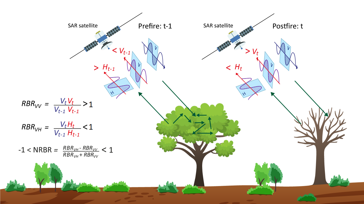
The NRBR is a novel SAR-based index derived from Sentinel-1 C-band Synthetic Aperture Radar (SAR) data, designed to enhance burned area mapping by capturing fire-induced structural and dielectric changes in vegetation. The NRBR leverages the complementary responses of VV (Vertical transmit-Vertical receive) and VH (Vertical transmit-Horizontal receive) polarizations to improve detection accuracy across diverse land cover types and moisture conditions.
1. Equation
The NRBR is calculated as follows:
$$ NRBR = \frac{RBR_{VH} - RBR_{VV}}{RBR_{VH} + RBR_{VV}} $$
Where:
- \(RBR_{VH}\) and \(RBR_{VV}\) are the Radar Burn Ratios for VH and VV polarizations, respectively, computed as the ratio of post-fire to pre-fire backscatter coefficients (\(\sigma^0\) or \(\gamma^0\)) in power units.
2. In-depth understanding
Burned areas generally exhibit reduced vegetation biomass and altered soil moisture, which influence the backscatter signal of VV and VH polarizations. The idea behind the NRBR is based on the fact that when vegetation is burned, the leaves are removed and the prevalent scattering structure is vertically oriented due to the presence of remaining stems and branches (Tarazona et al., 2025), the latter being particularly relevant for C-band scattering. This vertical structure contributes to the increased returns in burned areas than unburned areas for the VV polarization as the attenuating layer (leaves) is removed. For the VH polarization, which is more sensitive to volumetric dispersion and thus the tridimensional structure of the forest, the burned areas exhibit lower return power than the unburned areas. Therefore, NRBR may improve the contrast between burned and unburned areas (figure below) with burned scars showing negative values and areas of no change showing positive values. This conceptualization of the NRBR index is in line with other optical indices such as Normalized Burn Ratio (NBR) or Normalized Difference Vegetation Index (NDVI).
Let us consider the following illustration as an example: for a burned area, the \(RBR_{VH}\) values will be less than 1, so the numerator \(RBR_{VH}-RBR_{VV}<0\) (negative), and the denominator \(RBR_{VH}+RBR_{VV}>0\) (positive). Therefore, the division \(RBR_{VH}-RBR_{VV}/RBR_{VH}+RBR_{VV}\) will compute substantially negative values for burned areas. This same reasoning applies to unburned areas, where \(RBR_{VH}>1\) and \(RBR_{VV}<1\), so that the numerator \(RBR_{VH}-RBR_{VV}>0\), divided by the denominator \(RBR_{VH}+RBR_{VV}\), will result in computing unburned areas with positive values.
3. Interpretation
- Negative values: Indicate burned areas due to reduced \(RBR_{VH}\) (loss of volumetric scattering) and increased \(RBR_{VV}\) (enhanced backscatter from exposed vertical structures).
- Positive values: Represent unburned or unchanged areas.
4. Key Highlights
The NRBR index mitigates common SAR limitations such as speckle noise and topographic effects. By computing pre- and post-fire backscatter differences, NRBR reduces i) random speckle in a manner similar to multi-temporal filtering and ii) because both pre- and post-fire acquisitions are equally affected by topography, their ratio used cancels out topographic influences, removing the need for additional terrain normalization procedures.
Advantages over other indices
- Robustness to Atmospheric Conditions: Unlike optical indices (e.g., dNBR: delta Normalized Burn Ratio), NRBR is unaffected by clouds, smoke, or solar illumination, making it ideal for fire monitoring in persistently cloudy regions.
- Topographic and Speckle Noise Mitigation: Temporal ratios minimize terrain-induced distortions and speckle noise inherent in SAR data.
- Dual-Polarization Sensitivity: Combines VV (sensitive to vertical structures) and VH (sensitive to canopy volume), enhancing discrimination of burned areas across forests, shrublands, grasslands, and moisture conditions.
- All-Weather/Day-Night Capability: Enables continuous monitoring, unlike optical sensors that rely on clear-sky conditions.
Integration with Deep Learning
The NRBR is integrated into a U-Net architecture for semantic segmentation. Key enhancements include:
- Late Fusion: Combines NRBR and dNBR probabilistic outputs to reduce errors.
- Scalability: Implemented in Google Earth Engine and TensorFlow, enabling global, near-real-time applications.
Broader Applications
Beyond burned area mapping, NRBR shows potential for:
- Fire severity assessment: Correlates with optical indices (dNBR, dNDVI).
- Post-fire recovery monitoring: Tracks vegetation regrowth via temporal backscatter trends.
- Disturbance mapping: Detects deforestation or agricultural changes under cloud cover.
Conclusion
The NRBR represents a significant advancement in SAR-based wildfire monitoring, offering a cloud-resilient, high-accuracy alternative to optical indices. Its integration with deep learning and multi-sensor fusion (Sentinel-1/2) provides a scalable solution for global burned area mapping, particularly in challenging environments.